Map and History of Nigeria (Georeferenced)

The Federal Republic of Nigeria, commonly referred to as Nigeria (/naɪˈdʒɪəriə/), is a federal republic in West Africa, bordering Niger in the north, Chad in the northeast, Cameroon in the southeast, and Benin in the west. Its coast in the south is located on the Gulf of Guinea in the Atlantic Ocean. The federation comprises 774 Local Government Areas, 36 States, and 1 Federal Capital Territory, where the capital, Abuja is located. In some contexts, the states are aggregated into six geopolitical zones: North West, North East, North Central, South East, South-South, and South West. Each Local Government Area in Nigeria is administered by a Local Government Council headed by a chairman who is the Chief Executive of the L.G.A and other elected members who serve as Councilors. Under the Nigerian Constitution, states have the power to ratify constitutional amendments. The Nigerian traditional states predate all the modern states but have no legal or administrative powers.
As sovereign entities, States of Nigerians have the right to organize/structure their individual governments in any way within the parameters set by the Constitution of Nigeria.
LEGISLATIVE - At the State level, the legislature is unicameral, with the number of its members equal to three times the number of legislators it has in the Federal House of Representatives. It has the power to legislate on matters on the concurrent list.
LEGISLATIVE - At the State level, the legislature is unicameral, with the number of its members equal to three times the number of legislators it has in the Federal House of Representatives. It has the power to legislate on matters on the concurrent list.
EXECUTIVE - At the State level, the head of the executive is called the Governor, who has the power to appoint people to the State Executive Council, subject to the advice and consent of the State House of Assembly (Legislature). The head of a ministry at the State level is called a commissioner, who is assisted by a permanent secretary, who is also a senior civil servant of the State.
EVOLUTION OF NIGERIAN STATES
| Date | Events | Map |
|---|---|---|
| 1960-1963 | At the time of independence in 1960, Nigeria was a Federal State of three Regions: Northern, Western, and Eastern. Additionally, provinces, which were a legacy of colonial and protectorate times, remained extant until they were abolished in 1976. | 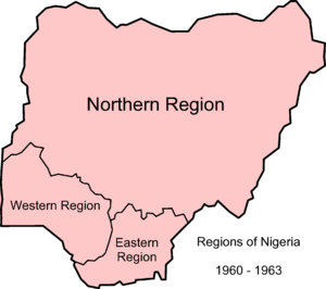 |
| 1963-1967 | In 1963, two provinces were detached from the Western Region to form the new Mid-Western Region. |  |
| 1967-1976 | In 1967, the regions were replaced by 12 states due to a military decree; only the former Mid-Western Region escaped division, and formed a single state following the restructuring. From 1967 to 1970 the Eastern Region attempted to secede, as a nation called Biafra during the Nigerian civil war. | 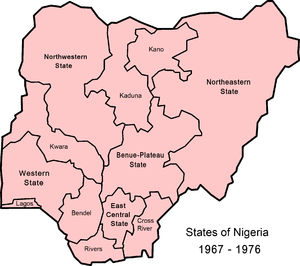 |
| 1976-1987 | In 1976, seven new states were created, making 19 altogether. | 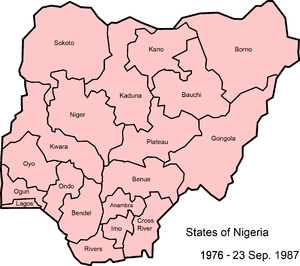 |
| 1987-1991 | During this period, there were 21 states and later, Abuja, the Federal Capital Territory. | 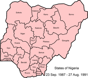 |
| 1991-1996 | During this period, there were 30 states and the Federal Capital Territory. The Federal Capital Territory was established in 1991. In 1987 two new states were established, followed by another nine in 1991, bringing the total to 30. The latest change, in 1996, resulted in the present number of 36 states. | 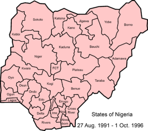 |
CHRONOLOGY
| Regions | States | |||||
|---|---|---|---|---|---|---|
| 1960 | 1963 | 1967 | 1976 | 1987 | 1991 | 1996 |
| Eastern | South-Eastern | Cross-River | Akwa Ibom | |||
| Cross-River | ||||||
| East Central | Imo | Imo | ||||
| Abia | Abia | |||||
| Ebonyi | ||||||
| Anambra | Enugu | |||||
| Enugu | ||||||
| Anambra | ||||||
| Rivers | Bayelsa | |||||
| Rivers | ||||||
| Western | Mid-Western | Bendel | Delta | |||
| Edo | ||||||
| Western | Lagos | |||||
| Western | Ogun | |||||
| Ondo | Ekiti | |||||
| Ondo | ||||||
| Oyo | Osun | |||||
| Oyo | ||||||
| Northern | Benue-Plateau | Plateau | Nasarawa | |||
| Plateau | ||||||
| Benue | Benue | |||||
| Kogi | ||||||
| Kwara | ||||||
| Kwara | ||||||
| Kano | Jigawa | |||||
| Kano | ||||||
| North Central | Kaduna | Kaduna | ||||
| Katsina | ||||||
| North Western | Niger | |||||
| Sokoto | Kebbi | |||||
| Sokoto | Sokoto | |||||
| Zamfara | ||||||
| North Eastern | Bauchi | Bauchi | ||||
| Gombe | ||||||
| Borno | Borno | |||||
| Yobe | ||||||
| Gongola | Adamawa | |||||
| Taraba | ||||||
GEOGRAPHY AND GEOLOGY
Nigeria is located in western Africa on the Gulf of Guinea and has a total area of 923,768 km2 (356,669 sq mi), making it the world's 32nd-largest country. It is comparable in size to Venezuela and is about twice the size of the US state of California. Its borders span 4,047 kilometers (2,515 mi), and it shares borders with Benin (773 km or 480 mi), Niger (1,497 km or 930 mi), Chad (87 km or 54 mi), and Cameroon (including the separatist Ambazonia) 1,690 km or 1,050 mi. Its coastline is at least 853 km (530 mi). Nigeria lies between latitudes 4° and 14°N, and longitudes 2° and 15°E.

The highest point in Nigeria is Chappal Waddi at 2,419 m (7,936 ft). The main rivers are the Niger and the Benue, which converge and empty into the Niger Delta. This is one of the world's largest river deltas and the location of a large area of Central African mangroves.
Nigeria has a varied landscape. The far south is defined by its tropical rainforest climate, where annual rainfall is 60 to 80 inches (1,500 to 2,000 mm) a year. In the southeast stands the Obudu Plateau. Coastal plains are found in both the southwest and the southeast. This forest zone's most southerly portion is defined as a "saltwater swamp", also known as a mangrove swamp because of the large number of mangroves in the area. North of this is fresh water swamp, containing different vegetation from the salt water swamp, and north of that is a rainforest.
Nigeria's most expansive topographical region is that of the valleys of Niger and Benue river valleys (which merge into each other and form a Y-shape). To the southwest of Niger is a "rugged" highland. To the southeast of the Benue are hills and mountains, which form the Mambilla Plateau, the highest plateau in Nigeria. This plateau extends through the border with Cameroon, where the montane land is part of the Bamenda Highlands of Cameroon.
The area near the border with Cameroon close to the coast is rich rainforest and part of the Cross-Sanaga-Bioko coastal forests eco-region, an important center for biodiversity. It is a habitat for the drill monkey, which is found in the wild only in this area and across the border in Cameroon. The areas surrounding Calabar, Cross River State, also in this forest, are believed to contain the world's largest diversity of butterflies. The area of southern Nigeria between the Niger and the Cross Rivers has lost most of its forest because of development and harvesting by increased population, with it being replaced by grassland
Everything in between the far south and the far north is savannah (insignificant tree cover, with grasses and flowers located between trees). Rainfall is more limited, to between 500 and 1,500 millimeters (20 and 60 in) per year. The savannah zone's three categories are Guinean forest-savanna mosaic, Sudan savannah, and Sahel savannah. Guinean forest-savanna mosaic is plains of tall grass interrupted by trees. Sudan savannah is similar but with shorter grasses and shorter trees. Sahel savannah consists of patches of grass and sand, found in the northeast. In the Sahel region, rain is less than 500 millimeters (20 in) per year and the Sahara Desert is encroaching. In the dry northeast corner of the country lies Lake Chad, which Nigeria shares with Niger, Chad, and Cameroon.


Comments
Post a Comment